GEOrient 9.4

This program plots and analyzes diagrams of geological structural data
4 
Rating
Your vote:
Latest version:
9.5.1 See all
Developer:
R J Holcombe
Screenshots
1 / 5
Awards (2)
Show all awards
Software Informer Editor Rating 4 Software Informer Virus Free award
Download

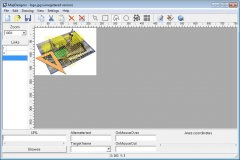
For plotting diagrams of geological structural data, rose diagrams and analysis, the GEOrient program is a handy orientation application for you. Your data can be copied and pasted from external spreadsheets or tables displayed in a map or even from GIS map databases. The program allows you to plot your data as great circles, beta intersections or as point symbols and you can also include numeric or non-numeric information such as length, weighting factors, assay values, and other classifications for diagram options. Great circles, beta axes and variance statistics are automatically calculated for you and small circles and other girdles can be added to your data simply by dragging and dropping with your mouse control.

GEOrient also allows you to merge multiple files as a single dataset and you can overlay them as separate plots using different symbols. You can open and arrange multiple plot windows on a page prior to printing too. Your diagrams can be rotated in various ways and linked fault plane and slip data can be plotted as slip arrow plots or as kinematical axes plots. Any symbol or colored annotated point can be overlain on the basic plot and registered users can display up to 99 simultaneous plots.

LS Senior editor
Luis Sanchez
Editor rating:
rating

Review summary

Pros

  • Data can be copied and pasted from external applications

Cons

  • Nag screen and plot windows restricted to 3 on unregistered copies

Comments (3)

User

Your vote:

B
rating Bob
Nice program that is very convenient for displaying orientation data. Pity Windows 10 does not support the GEOrient Help facility. It would be useful to know what file type (e.g. .txt) would be useful for entering secondary data, how to ensure that the secondary data gets plotted (such as slickenlines and sense of slip on to primary data such as planes) and how to them use those data for P-T plots. It is a basic need, is probably very simple but it is not intuitive (although very easy on a paper stereo net) and GEOrient does not have any explanatory notes included in the download (georient.exe) file.

Was it helpful?  yes(0) no(0) | Reply
G
Guest
Hello, I am using Mac. I have downloaded Georient but when I try to open the program, it says 'The program cannot be run in DOS mode' .

Just wondering how I can change/fix this.

Was it helpful?  yes(1) no(0) | Reply
G
Guest
Georient does not work on Mac, try using Stereonet 9 software.

Was it helpful?  yes(0) no(1) | Reply

Related software

HP Trust Circles
HP Trust Circles
Free
rating

Provides data containment by cryptographically binding data to a group of users.

Net Deed Plotter
Net Deed Plotter
rating

Draw and analyze legal descriptions for the real estate business.

Strategy Map Balanced Scorecard
Free
rating

Create your own strategic picture and control organizational operations.

Map Designer
Map Designer
rating

Client-side and server-side Image Mapping Utility.

ArtRayd Circles
ArtRayd Circles
Free
rating

Multiple nice colored circles flying around desktop making you relax.

Related suggestions

Tags

Data Map Beta GEOrient Circles